It's hard to believe that Fall Break happened over a week ago - with midterms, problem sets, and the poster session, time has been flying by here at SPH. Thankfully, Fall Break this year was actually a break (last year all of the midterms were after the break, so it was more of a "break from class so you won't be distracted while you study" type of a vacation), so I figured that I'd use the time to go explore Michigan. The area around Ann Arbor is nice - lots of rivers, streams, and lakes - but I'd never seen the northern half of Michigan and so decided to camp at Sleeping Bear Dunes for a few days. The weather was perfect - high 60s and sunny - and since it was the middle of the Fall, the campsites were fairly empty (at least we didn't have to contend with lots of loud RVs at night). We also managed to hit that point right before the leaves drop off the trees, so the drive north to Traverse City (only about 4 hours) had lots of nice scenery along the way. The camping was different than I'm used to (there was actually running water and permanent toilets!), so "roughing it" isn't really an apt description of the facilities. The park has lots of nice trails that wander through the dunes, and it's easy to forget that you're standing on sand that was dropped here at the end of last ice age when you're walking through the middle of a forest. Once you make it through the dunes, the views out over Lake Michigan and across to the Manitou Islands are great. There's even a dune climb where you can hike up the hills for a bit and over to the lakeshore (although running down on the trip back is more fun...). 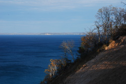 This trip was my first time seeing one of the Great Lakes, and it was weird to see waves in something that didn't have a salt spray. The more I explore Michigan, the more I come to like the state - it's much different than I had expected when I moved here, and there's lots of state parks and forests to explore. All in all, the trip up north was a great way to escape school and homework for a few days, and it's inspired me to plan a trip to the Upper Peninsula sometime next year - after the snows melt, of course.
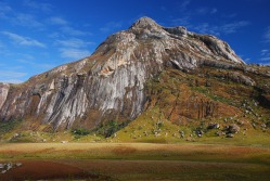 After climbing Mt. Mulanje over the weekend I no longer doubt that Chichewa has 13 words for "mud" and none for "switchback." Mulanje is not a typical mountain - it's more of a giant granite mesa that juts up from the surrounding tea estates. There are over 76 peaks on top of this plateau, but getting up to the plateau requires more than a bit of effort and covering almost 2,000 vertical feet in less than 2 miles. Just when you think you're doing well, your porters will pass you literally running up the mountain in bare feet (or if they feel the need to protect themselves, flip-flops).
 Once you finish the climb (after stopping every 20 minutes or so to catch your breath and enjoy the view out into Mozambique) you find yourself on a large plateau with some gently rolling hills. The landscape shares a strange affinity with some areas of Scotland, and this effect was heightened by the misty weather that rolled in every afternoon (we managed to visit during a chiperonde, which is a fancy word for cold, wet air blowing in from Mozambique that settles over Southern Malawi for days at a time). The mountain itself is an interesting place - local legend maintains that it is home to evil spirits (the name of the highest peak, Sapitwa, translates to "Don't go there.") and there are no permanent settlements on the plateau, but there are large tracts of Mulanje Cedar that the forestry department allows the locals to harvest.
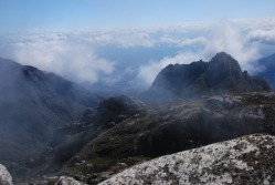
 We camped overnight in a hut which thankfully had a nice fireplace (temperatures dropped to below freezing soon after the sun went down) and woke up early the next morning to climb Namasile (pictured at the top), the second highest peak on the massif (and therefore in all of Malawi). The trail up the peak followed a stream bed over some rolling hills for about 30 minutes until we began the ascent - another hour of fairly uneventful steep slopes. Then we lost the trail. It happened at a large boulder that was totally overgrown with moss and trees (a very Indiana Jones-esque moment, especially when we found leopard scat in the cave we eventually had to crawl through). Apart from this small detour, the rest of the climb was uneventful and we made it to the summit just as the clouds rolled in and obscured our view of just about everything. Interestingly, the first thing our guide did was to bang a rock against a metal sign to scare the spirits away (although he claimed later that the myths were all lies told to impress the visiting white people). We made it down fairly quickly, camped overnight again, and then started down the plateau the next morning, which was certainly easier than it was going up. Once we made it down, we drove around the mountain and had lunch at, of all things, a Malawian-run Italian restaurant. Pizza and beer have never tasted so good.
 Malawi has odd visa requirements - you can stay in the country continuously for up to 3 months without any problems, but if you stay longer than 3 months than you must enter a nightmarish world of bureaucracy, fines, and paperwork to obtain a 6-month permit. However, if you leave the country after three months and re-enter, you can stay for another 3 with no problems. One of my housemates found himself in this situation, so we decided to resolve the problem in the only reasonable manner: by going on safari. Malawi has a few game parks and national preserves, but none compare to South Luangwa National Park in Zambia. Getting there was a bit of a challenge - 4 hours by bus to Lilongwe, then a 6-hour car transfer from Lilongwe (Malawi) to Mfuwe (Zambia), the last 3-hours of which are on an insanely bumpy and dusty road, and finally on to the park (after a two-hour stop at the border, the particulars of which still confuse me).
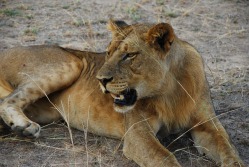
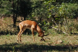
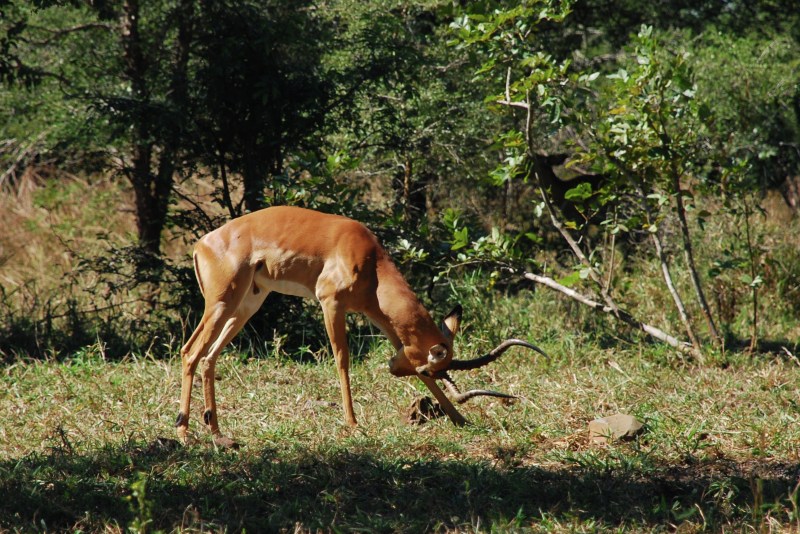
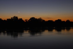 We arrived in camp around dusk, greeted by Moses (our guide) with the words "Do you want to see a crocodile?" (the answer is always yes). Disoriented from the ride, we walked about 25 feet and came to the riverbank, where we could see crocs and hippos about 10 yards away from us. After this introduction we had a brief speech about safety (don't walk alone at night; too many hippos and elephants - I thought they were joking but when I was woken up at 3AM by an elephant not three feet from my tent it became clear that that might actually be a Good Idea) and then it was off to dinner. Safaris start early (animals don't wait for people) and we hit the road at 6AM (wake-up call at 5AM) for our first trip into the bush. Honestly, I wasn't expecting much and told myself that I would be happy with seeing a few elephants, some grazers, and maybe a hippo, zebra, or giraffe. I was wrong. Within an hour we had found two lions and a herd of zebra, and before the drive was over we'd also seen 12 elephants and ambushed a herd of giraffes. The night drive (4PM to 8PM) was even better - it started off by watching a pride of lions stalk an impala (they failed), and then driving to within 2 feet of the pride, where the male proceeded to mate with the females (which they told is quite rare). Video (which is funnier than it should be) will be on YouTube soon.
As night fell, we focused on the one animal that we hadn't seen - a leopard. Although South Luangwa is one of the best places to see them, our guides warned us that we probably wouldn't get so lucky this time around. They were wrong - not only did we find a leopard with 15 minutes, we saw and helped it stalk an impala by using our car to provide cover. Stalking takes a long time, so we switched off the lights and sat in the dark for 15 minutes, listening to the impala bark at each other. We suddenly heard an impala bark much louder and then hooves running away, but when we switched the light back on we saw that the leopard had missed.
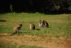 The camp at which we stayed was an adventure in itself - although we slept in tents, they had permanent beds and there were so few people that we each had a tent to ourselves so I'd hesitate to call it camping. Monkeys and baboons ran around the grounds at will, and woe be unto him who left food unattended for more than a few minutes (the monkeys are tricky devils). At night, hippos and elephants began their invasion, and you could count on waking up at least once a night thanks to nearby hippos, who are surprisingly fast out of the water.
The second day was just as exciting as the first - we saw more elephant herds, giraffes fighting, hippos eating, and a fantastic sunset over the river. We even managed to spot yet another leopard, although we only followed this one for a few minutes. After two days of safari, it was back to Blantyre, but South Luangwa is certainly a place I'd love to visit again.
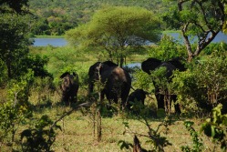 Blantyre is not the world's most exciting town. The city consists of a small downtown area with some shops, restaurants, and a moderate commercial district (one to two banks) surrounded by suburbs, with a small shopping center located near the hospital. Hanging around for the weekend is not exactly the most thrilling way to spend your time. Thankfully, Blantyre is surrounded by great opportunities - there are three mountains that you can climb within 10km of the city proper, and there are no less than 3 game reserves within an hour's drive. These game preserves are off the main tourist track so when we went to visit Majete Wildlife Reserve we had the park to ourselves - we saw one other car for the 6 hours that we were there. Combine the ease of access with the low entrance fee ($20 including gas to and from the park) and it's a perfect place to escape from Blantyre. I didn't expect much from the park - it looked fairly small on the map, but as soon as we drove in my mistake became apparent. The entrance to the park is next to Kapuchiri Falls, which stopped the famous Dr. Livingstone on his first attempt to travel up the Shire River into Malawi. On our way up from the falls we had to stop the car suddenly - 5 elephants chose that moment to cross the road and start grazing about 20 feet away from our car. Violating the first rule of animal safety, I of course got out of the car to take a few pictures (totally worth it) and through dumb luck or the elephants' friendliness I escaped unharmed (although we left the door open in case I should need to sprint back into the car and drive away).
 After spotting the elephants we hit a bit of dry spell (not that I'm complaining) were we saw mostly elands, impalas, and sable until reaching the "Hippo Spot", where, true to it's name, about 10 hippos were basking in the sun and sitting in the river. We carried on from this point to a loop around the park (thick underbrush does not a good chance to spot animals make) and were surprised by a massive herd of impala (60-80 strong) leaping across the road with four zebra in pursuit. The impala can jump - their hind legs go above their head and the highest point and it looks like the twisting will either break the back or force them to to tumble down, but they always seemed to land without even breaking stride. The park was devastated by poaching in the '80s and '90s, but starting in 2006 it has been the focus of an intensive plan to repopulate the park and increase the diversity. They've successfully imported 75 elephants from Liwonde National Park, and the herd now numbers 150. There are supposedly 7 rhinos hiding in the park somewhere, but they are rarely seen. The rangers also plan to introduce lions to the park in 2012, which will be a shock to the complacent population of grazers (I hope all the elands and zebras remember how to run...) but should also bring more visitors to the park.
 Mt. Michiru is a good-sized mountain, and since it makes for a nice outing on the weekends, we decided to climb it again this Sunday (this time the top wasn't covered in a fog bank, but we still didn't make it up early enough to avoid the dust and haze, so it looks like we'll have to return at some point). The only problem with this hike is the trails, which go straight up the hill. When the sun is shining, this approach is not so much fun (I'm not sure I'll ever adjust to the fact that it can be over 90 degrees in the winter here), so when we made it back down we were in need of some sustenance.
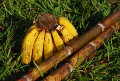
Fortunately, the drive from Mt. Michiru to the guesthouse passes through a market area, so we stopped off to pick up some food. Bananas, tomatoes, potatoes, and chickens (alive and dead, but in neither case plucked) were the most common items on offer, and since it is the sugarcane harvest season we also passed a few buckets of freshly harvested cane. Being the adventurous sort, we decided to stop and pick up some bananas and two sticks of cane - all for less than $0.70. Both were delicious and made for a great snack after coming down the mountain, although eating the sugarcane was much more labor-intensive than I had expected - first you have to strip the bark (using a knife is smart but the Malawians use their teeth), and then you can get to the fibers which are soaked with the sugary water. Still, totally worth the $0.15 per stick.
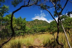 Working at a research institute is not always the most thrilling of pursuits (most of my internship involves staring at computers and working with databases) and it's always nice to escape the office for a while. In Michigan there aren't too many hilly places to go (the worst thing about the Midwest) so I was glad to find mountains all around Blantyre when I arrived in Malawi. Three mountains - Ndirande, Michiru, and Sochi - make a rough triangle around the city, and each one is self-contained nature preserve. Mt. Michiru was our first target, for no other reason than it was the closest and had a mountain to climb (the hint that leopards still lived in the park didn't hurt either). With our goal in mind, we sent off to Mt. Michiru over a less-than-perfectly-maintained road (yay for 4WD!), dodging monkeys and baboons along the way (I may have exaggerated slightly). We went up later on Saturday than planned, and by the time we got there the temperature was a bit high to attempt to climb to the top and decided to take a shorter trail that led over some hyena caves (we didn't see them, but if you stand right on top of one you can smell them - they smelled like wet dog). Other than this non-encounter with hyenas, monkeys were the most exciting wildlife on the hike (our guide was incredulous that we did not have monkeys in the US - in his words "No monkeys? Not even in National Parks!?!").
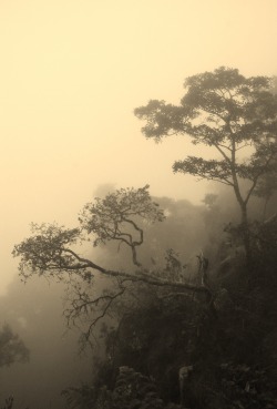 We returned to Mt. Michiru on Sunday and made it to the top this time - unfortunately, the weather was not cooperating and all we could see was the middle of the cloud bank that covered the summit (the picture shows how wonderful the visibility was). Although the mountain was only about 5,000 feet high, Malawi has not yet adopted the switchback - so the trails often go straight up the mountain. The benefit to this approach is that the trails are much shorter, but the downside is that people who are not-so-in-shape (like myself) have a more difficult time of it. Sadly we didn't have any encounters with Large African Mammals, but a group after us was running up the mountain away from a large viper. Since the mountain is easy to get to and has some pretty quick hikes that get you out of the city and into the field I'm sure that I'll be heading back fairly often during my stay.
After nearly 40 hours of continuous travel through three countries, including 3 flights, 2 (long) layovers, and a volcano scare, I've finally made it to Blantyre, Malawi, where I'll be working on my summer internship. Jet-lagged and confused, I landed in Lilongwe, the capital of Malawi, where I met a staff member from the Malaria Alert Center who happened to be in Lilongwe for sample collection and drove me down to Blantyre.
The road from Lilongwe to Blantyre was technically a highway, but not what you or I think of as a highway. Highways in Malawi are used by everyone - pedestrians and bicyclists often outnumbered the cars, and as it got darker I began to realize why traffic accidents are a leading cause in sub-Saharan Africa (hint: horns are not always effective at getting a cyclist or pedestrian to scoot over quickly). Most stalls, selling everything from fruit to cell phones to birds on a stick (fun fact: you can buy 5 roasted birds for 100 Kwacha, less than a dollar) set up right along the roadside - there are no real exits or even places to pull over safely off the road. 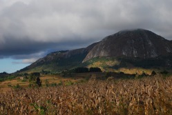 The scenery was amazing. What struck me first is how different everything is - the crows here have a whit torso, but otherwise look like the crows at home and the trees look different, although I can't quite put my finger on why that is. The daily life in Malawi is, obviously, very much not like that in America, and it's easiest to see in how young the population is (most people look to be younger than 25) and by how much work the children have to do. I saw at least 20 kids under the age of 8 herding goats and cattle on the side of the road - one 6-year old was able to herd 20 cattle with just a stick and lots of running. So after the trip, I'm finally settled in to the guesthouse in Blantyre and ready to start my summer internship - I can't wait.
 It's hard to believe that I'm halfway done with my MPH - the first year went by too quickly, and the end of the year stress (finals, final projects, etc.) helped it to fly by even more quickly. After finals ended, I noticed something strange - the snow was gone and the weather was gorgeous (lows in the 50's, highs in the mid-70's... while winter is brutal it is hard to dislike MI in the spring). Given the nice new weather, I decided to explore MI a bit with another epidemiology student, and we found two nice hikes that were good escapes from Ann Arbor.
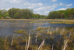
One thing that I miss in MI are the hills - I could see mountains from my undergrad and hometown, and when I worked in Germany I was in one of the hillier regions, so MI is oddly flat to me. Since I was used to this terrain, I just assumed that hiking = walking around in hills and mountains, and that hiking around a flat plain wouldn't be all that much fun. Needless to say, I was wrong. We found a bog near Kalamazoo (yes, that's a real place name) and decided that it would make for an interesting adventure, seeing as how I'd never seen a bog before. It was a nice change from the hills and mountain streams that I was used to - all of the plants were different, there were more birds, and there were a few snakes and frogs to keep things interesting. 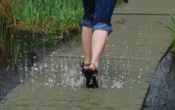 However, the trail was probably the most fun part of the hike. It went right over the bog (I'm not sure how they did it, the plastic boards didn't seem to be anchored to the ground but they were very stable) and if you moved too quickly you could get a bit wet. We didn't expect that the trail would fight back, so the first few steps were a bit wetter than we had anticipated, but after getting adjusting for the surprising squirts it was a nice way to cool off and it always made for a nice surprise. On the way back from Bishop's Bog, we stopped at Bell's Brewery, which has some of Michigan's best local beer and should be a required stop if you find yourself in the area.
I'll be heading off to Malawi for my summer internship soon (more on that later), but when I get back to MI I'm looking forward to exploring more of what the state has to offer - especially since I'll only have one more year to take advantage of it.
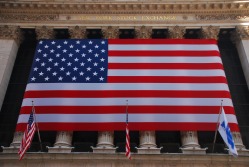 Apologies for not updating sooner; the readjustment process has been chaotic (putting it mildly) and the blog here fell off my radar screen for a while. My last week in Germany was also rather busy, between some traveling in the region (post on Eisenach coming soon) and the annual MPI soccer tournament. I'm happy to say that our team (the Rocket Cows) came in 5th overall (out of 12), which isn't too bad for never having practiced. My arrival in the US kept the general level of activity high - a few days after arriving we left for a family vacation to New York City (my first time there), where we had a great time. Pictures for the interested. NYC was a shock - even the largest cities I'd seen in Europe couldn't compare to the overall activity level of NYC, and the massive American flag presence (it seemed like every street corner...) made sure that I knew where I was.
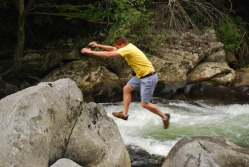 I've also been getting my fair share of US (well, southern US) "culture" - lots of BBQ and grilling, as well as going shooting and "creek walking". Creek walking was new to me but it's becoming one of my favorite activities. It consists of finding a creek, and then seeing how far up the creek you can travel without getting wet, with crossing from one to the other as you see fit to add a challenge. The creeks here in the Smoky Mountains are riddled with boulders, so moving up the creek requires a combination of climbing, jumping, and creative movement skills (as seen by my friend Cisco's boulder hopping in the picture). Of course, you end up getting wet (falling in, misjudging a jump, slipping on moss...), and then walking back through the cold water on a warm day just adds to the fun.
After this pleasant interlude, I'll be heading off to the University of Michigan early tomorrow morning, which will require me to re-enter academic mode and see how well I actually tolerate cold environments (I'm hoping well, but lake-effect snow scares me). Starting my MPH is exciting, and I'm looking forward to the new curriculum and opportunities.
In a somewhat more intellectual vein, I recently had a paper published - it's not accessible online yet (unless you're luck enough to have a subscription through a university) but you can find the abstract here. Needless to say, I'm very excited and will share the paper here if possible (i.e. if it ever becomes open-access).
 The border crossing is almost imperceptible now. There are no checkpoints, no guards, and no barbed wire. But you notice that things are somehow different here in the former German Democratic Republic, even 20 years after the German reunification. It's not a change that you can put your finger on - it might be the juxtaposition of the shining restorations with the crumbling factory buildings, or it might be the broken windows that suddenly seem to be everywhere. This visit marks my first trip to Eastern Germany - downtown Berlin hardly counts - and my first time on the German coast. We came here on a whim, and it proved to be a strange mix of the comfortably familiar and the decidedly foreign. Not bad for a six-hour train ride.
We arrived in the town of Wismar about one hour after leaving Hamburg, one of Germany's wealthiest cities. In a way, the towns are subtly linked - in the 13th and 14th centuries they were both prosperous trading towns and members of the Hanseatic League. Both of their harbors are well-protected, with Hamburg's opening onto the North Sea and Wismar's facing the Baltic. Due to the vagaries of history, the similarities end here - Wismar is now a town of approximately 45,000, while Hamburg's population is well over 1 million. After the brutal 30 Year's War - which saw Germany's population decrease by over 1/3 - Wismar came into the possession of Sweden and was not returned to Germany until 1903. After returning to German possession, manufacturing took off in a big way here, helped by the deep harbor, which made shipping much easier. Dornier made it their headquarters in North Germany for plane and rail production, and this combination made it a wonderful target for Allied bombing raids, contributing greatly to its decline. Even though it was briefly occupied by British and Canadian forces, it soon fell into the hands of the Soviets and ended up in the GDR.
 The fact that the Soviets occupied Wismar for so long is apparent on every street. In Western Germany, the war damage was quickly repaired, factories were rebuilt, and these rebuilding measures were encouraged and supported by the occupying powers. In the GDR, the philosophy of the occupying forces ran more along the lines of "take what you can and destroy the rest." When cathedrals all over Western Germany were being rebuilt, the Soviets bombed what was left of the ruins of the church of St. Marien - reconstruction was too expensive and the church didn't get on well with the government.
Given this sad history, you'd expect Wismar to be a shell of its former self, but it's not - it's an absolutely gorgeous city that feels alive and well-connected to it's history. The citizens are proud (and rightfully so) of their maritime history and traditions, and since reunification the town has seen a major comeback. Tourism (mostly other Germans) is booming, and the church of St. Marien is even slated for reconstruction. Ships of all periods (we saw a cutter from the 19th Century and a reconstructed medieval cog, as well as countless fishing boats) offer tours of the harbor and Baltic Coast. Most of the city's monuments have been recently restored (or are in the process) and the city is once again starting to shine, helped by it's unique Hanseatic architecture (Wismar and Stralsund are UNESCO listed for this very reason). This former glory is especially prominent in the Church of St. Nikolai, which escaped the war with hardly a scratch and whose exceptionally well-preserved interior and frescoes truly amaze (and I've long since reached the "just-another-church" phase.) However, the scars of the past remain - next to every reconstructed building is a ruined house or abandoned factory.
The harbor was and remains the true heart of the town. This place is where the locals and tourists mix, reflected in the mixture of fishing trawlers and pleasure yachts. It was far and away my favorite place in the city - it was very pleasant to walk up and down and you could buy more German sushi - this time in the form of Matjes (raw herring filets dipped in a salty oil and served on a roll with onions) - directly from some of the fishing boats, which had been refitted into floating markets. They taste much better then they sound. There's also a small brewery (the only one in town) tucked up against the harbor which produces an extremely good Maibock. The brewery serves as a nice reminder of the city's glory days - back in the Hanseatic period there were over 150 churning out an impressive 400,000 hectaliters per year.
 As much as we liked the town, it was just a bit small to be able to spend two full days there, so on our second day we rented bikes from the hostel and went off into the countryside. Like most German towns, the agriculture/national preserves/rural areas begin right where the town ends. Wismar is especially blessed in this regard, as a wide peninsula stretches up from the harbor to the Isle of Poel, providing great views across a fairly flat landscape. The bike path follows this peninsula north, where it passes through fields and pastures, and the yellow of the rapeseed flowers set off the green fields and blue sea nicely. On our way to the island we passed by old thatched roof houses and a stable, but the past was present even here: a concrete ship used by Dornier as a practice bombing target still stands wrecked on the shore.
After about six miles we reached the island itself (calling it an island is debatable, as you can walk there at low tide) where we had a great time just biking around. Traffic was low enough for us to bike along the main road up to the beach resort area, and from there we switched to a dirt path that followed the coast fairly closely. After a quick stop for lunch (and beer, naturally) overlooking the cliffs and beaches we kept along the shore until we found a nice, free beach (almost nothing is free in Germany, including use of some public beaches) where we stopped for a bit so that I could walk into the Baltic. Sadly, the older gentlemen down the beach took "free" to a whole new level and we had the joy of seeing them exactly as nature had intended. After our break we started to head back, where we passed by a memorial to the Cap Arcona - erected, ironically, by the Soviets themselves. About halfway into the return trip the decision to rent the cheaper bikes came back to bite us, so we kicked up the pace and headed back for a well-earned stop at the brewery and a padded seat.
The next morning we were getting ready to leave when the man who had rented us the bikes started to talk to us. I had known that the East Germans were not the happiest of people (going through three governments, two of them dictatorships, in four generations will do that to you) but I was not really prepared for this. I couldn't really nail down his political views - he would jump from socialist to free-market capitalist from sentence to sentence - but the frustration with the system is what came through the most. Mecklenburg-Vorpommern is one of the poorest states in Germany, and political radicalism on both wings is high (the NPD, the closest thing Germany has to a neo-nazi party, gets 7.3% of the vote here). All the run-down buildings and ruined factories we had seen seemed to lead up to this conversation - a personal account which vividly demonstrated that the East still has a long way to go before all of the gaps are closed. Six more hours on a train and a border crossing later, I was back in Marburg.
For the interested, more photos can be found here.
|


 RSS Feed